
The Indian Subcontinent
Location : Indian subcontinent comprises of India, Pakistan, Bangladesh, Nepal and Bhutan. The subcontinent extents between 80 4’N and 370 6’N latitudes and between 680 7’E and 970 25’E longitudes. If we add the sixth country Sri Lanka then it starts from 60N latitude. Through the middle of India the tropic of cancer passes.
Size of subcontinent : The total area of Indian subcontinent is 44.9 lakh sq.km. India is 3287263 sq.km, Pakistan 796095 sq.km, Bangladesh 148393 sq. km, Nepal 147181 sq. km, Bhutan 46500 sq. km and Sri Lanka 65610 sq. Km. The length of Indian subcontinemt from North to west it is 3000 Km.
Indian Standard Time (IST) is 5½ hours ahead of Greenwich Mean Time (GMT). This meridian (82½0E) dictates time in Sri Lanka and Nepal also.
Political Division of India
Politically India is divided into 28 states and 7 union territories.
Locational Advantage of India
India is situated on one of the peninsulas of southern Asia. India extends from Kashmir in the north to Kanyakumari in the south. The Arabian Sea and the Bay of Bengal are situated on either side of peninsular India. The latitudinal extent of the country is from 804′ North to 3706′ North. The Tropic of Cancer (231/20N) passes through the middle of the country. The longitudinal extent of the country measures from 680 7’E to 970 25’E. The country is located in the northern and the eastern hemispheres. The importance of location of India is that it is located on the world’s major sea routes. Due to its location, India has maritime contacts with south-west Asia and Africa on the west and south-east Asia in the east. Its location has an advantage of the route of the Suez Canal for trade with North America and Europe.
Size of India in terms of Area and Population
Our country is the seventh largest country in the world. The area of India is about 3.28 million sq.km. The area of India is equal to the continent of Europe excluding Russia. The size of India is about eight times as large as Japan. India is the second largest country in terms of population next to China. No continent of the world except Asia has a large population than that of India. India has about one-sixth of the total population of the world.
Physical Division of the
Indian Subcontinent
A chain of high mountains start from the Pamir Knot. This knot lies just in the north of India. In these mountains the Hindukush, the Sulaiman and the Kirthar in the east and the Himalayas in the west separate the Indian subcontinent from rest of Asia.
Indian subcontinent has the following physical divisions : (i) The Great Mountain Wall of the North, (ii) The Great Northern Plains, (iii) The Great Peninsular Plateau, (iv) The Coastal Plains, (v) The Great Indian Desert, and (vi) The Island Groups.
(i) The Great Mountain Wall of the North
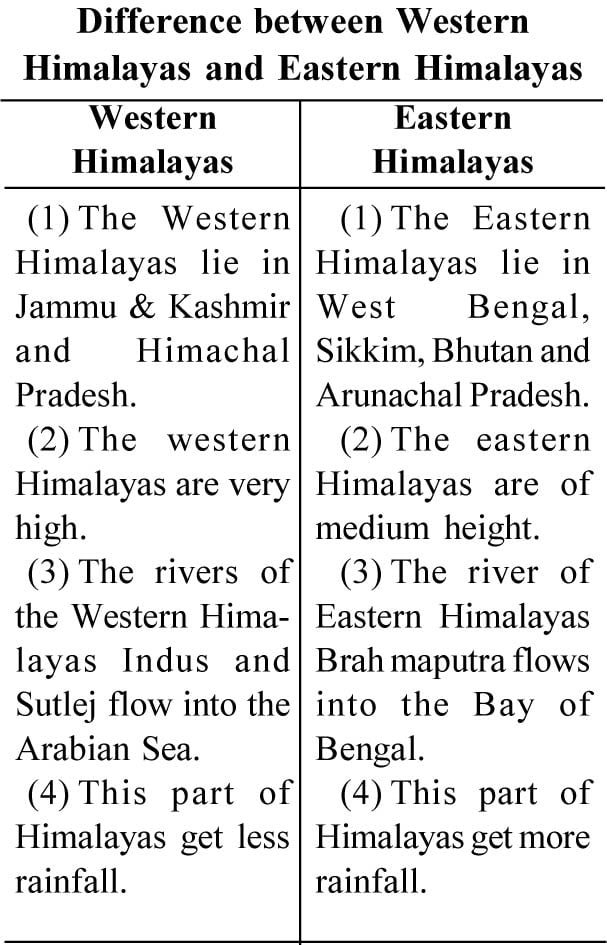
The northern boundary of India is occupied by the great range of Himalayas. From west to east the Himalayas are 2500 km. long and their average breadth is between 250 km. to 400 km. Mount Everest, the highest peak in the world, lies in these mountains in Nepal. Its height is 8848 m.
Division of the Himalayas : The Himalayas have three parallel mountain ranges :
(a) The Greater Himalayas : Mount Everest lies in this range. Some of the important passes in this range are Zozila, Jolpala and Lingshila. These snow-covered mountains give birth to many glaciers. River Ganga originates from this glacier.
(b) The Lesser Himalayas or the Himachal Himalayas : This range lies from west to east. This range is 60 to 80 km wide and its mean height is between 3500 to 4500 metres. Tourist places like Shimla, Mussoorie and Nainital lie in this range.
(c) Shivaliks or the Outer Himalayas : This is the southern range of the Himalayas with an average height of 900 to 1200 metres. It’s breadth is only 10 to 50 km. In the west is the Shivalik range.
(ii) The Great Northern Plains
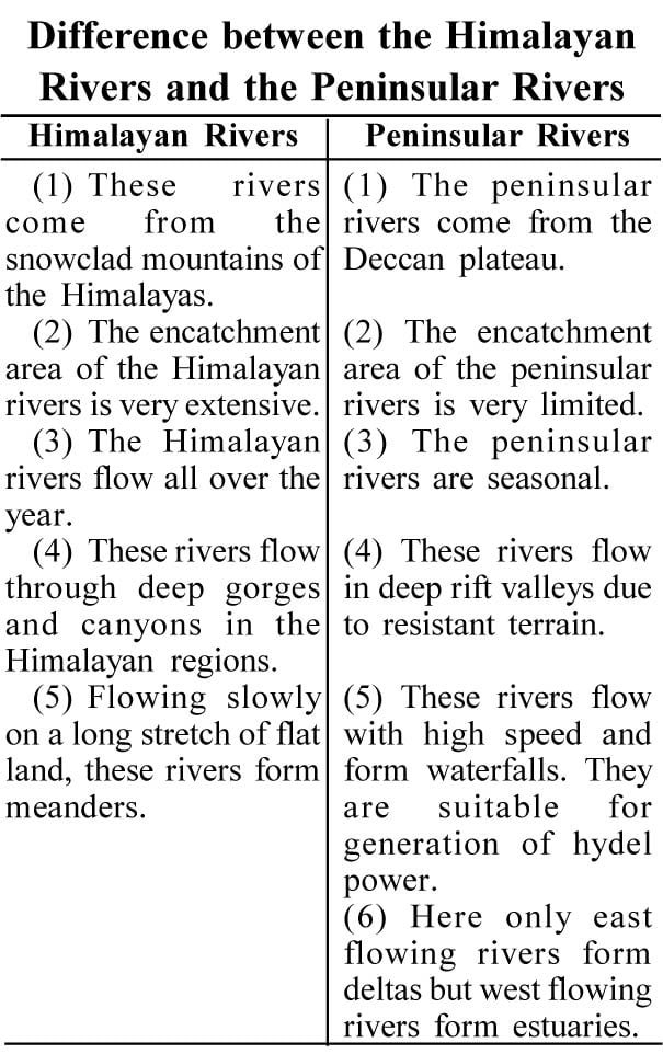
The northern plains have three sub-divisions. These divisions are the Punjab and Haryana plains, the Gangatic plains and the Brahamaputra valley. The Gangatic plains constitutes the largest lowland drained by the Ganga and its tributaries like Yamuna. Ghaghara, Gandak, Kosi and Tista are other tributaries of the Ganga. Other tributaries of Ganga are Sone and the Damodar and the Chambal and the Betwa are tributaries of the Yamuna from the peninsular plateau. The Gangatic plain has an extremely gentle slope. Parts of this plain are subjected to floods in the rainy season. In the lower course, the Ganga divides itself into tributaries to form a large delta along with the Brahmaputra. The Punjab and Haryana plains represent a part of the Indus basin. A low watershed separates these plains from the Gangatic plains.
(iii) The Great Peninsular Plateau
The Deccan plateau goes to the south of the Vindhyas. The western edge of the plateau rises steeply from the Arabian Sea and is known as the Western Ghats. There is a gentle slope towards the east of Deccan Plateau. The elevation ranges from 300 to 900 metres. The eastern edge of the plateau is known as the Eastern Ghats. The north-western region of the Deccan plateau is covered by nearly horizontal sheets of lava. This region is called the ‘Deccan trap region’. The Deccan plateau is drained by many long east flowing rivers. These rivers originate in the Western Ghats, flow towards the east and enter the Bay of Bengal. Godavari, Mahanadi, Krishna and Cauvery are the major rivers that have built deltas along the coast. Narmada and Tapti rivers flow to the west and enter the Arabian Sea along the Gujarat coast. These rivers do not have deltas. Along the margins of Deccan plateau, there are coastal plains.
(iv) The Coastal Plains
Strips of flat land on eastern and western coasts are called as the East Coastal Plain and the West Coastal Plain respectively.
(a) The West Coastal Plain : It lies between the Arabian Sea and the Western Ghats and spreads from Gujarat in the north to Kanyakumari in the south. This uneven plain has many fast flowing rivers. Its northern part from Gujarat to Goa is called Konkan, while southern part from Goa to Kanyakumari is known as Malabar. Several lagoons are found on this coastal plain. Several ports developed on its coast from north to south are : Kandla, Mumbai, New Jawahar Port Mumbai, Marmagao, Mangalore and Cochin.
(b) The East Coastal Plain : This plain goes along the Bay of Bengal from Orissa in the north to Kanyakumari in the south. Its northern portion is called as Northern Circar plains and the southern portion is called Coromandel Coast on this plane, rivers like Mahanadi, Godavari, Krishna and Cauvery form deltas. This coast is well known for rice cultivation. A large number of lagoons are also found here. Chilka and Pulicat lakes are quite famous.
(v) The Great Indian Desert
The great Indian desert lies to the west of the Aravali range. The major part of this desert is in Rajasthan and Sindh in Pakistan. Rains are not much in this desert, as the Aravali range run parallel to the south-western monsoon winds. It is in the rain shadow area of the Bay of Bengal current. The desert is covered with sandy soil. It is a dry area with hardly any rivers. Lake Sambhar is found here.
(vi) The Island Groups
1. Apabian Sea has Lakshadweep as a group of 36 coral islands. It is located 300 km to the west of the coast of Kerala.
2. Andaman and Nicobar Islands are a group of about 324 islands. Most of these islands are uninhabited.

Comparison of the Western Ghats and the Eastern Ghats
(i) The Western Ghats run parallel to the western coastline, whereas the Eastern Ghats run parallel to the eastern coastline of India.
(ii) The height of the Western Ghats is more while the Eastern Ghats are lower.
(iii) The Western Ghats are a continuous range, but the Eastern Ghats are discontinuous.
(iv) In Western Ghats rainfall is in summer only, whereas in eastern Ghats get rainfall is both in winter and summer.
(v) The Western Ghats enclose a narrow plain between its western slope and the Arabian Sea, while the Eastern Ghats enclose a wider plain between its eastern slopes and the Bay of Bengal.